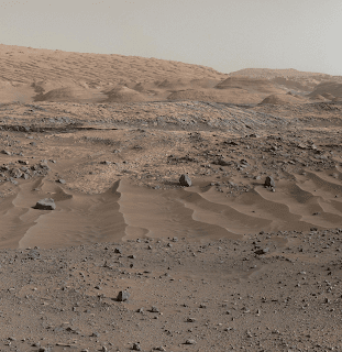
A southward-looking panorama combining images from both cameras of the Mast Camera (Mastcam) instrument on NASA's Curiosity Mars Rover shows diverse geological textures on Mount Sharp.
Three years after landing on Mars, the mission is investigating this layered mountain for evidence about changes in Martian environmental conditions, from an ancient time when conditions were favorable for microbial life to the much-drier present.
Gravel and sand ripples fill the foreground, typical of terrains that Curiosity traversed to reach Mount Sharp from its landing site. Outcrops in the midfield are of two types: dust-covered, smooth bedrock that forms the base of the mountain, and sandstone ridges that shed boulders as they erode. Rounded buttes in the distance contain sulfate minerals, perhaps indicating a change in the availability of water when they formed. Some of the layering patterns on higher levels of Mount Sharp in the background are tilted at different angles than others, evidence of complicated relationships still to be deciphered.
The scene spans from southeastward at left to southwestward at right. The component images were taken on April 10 and 11, 2015, the 952nd and 953rd Martian days (or sols) since the rover's landing on Mars on Aug. 6, 2012, UTC (Aug. 5, PDT). Images in the central part of the panorama are from Mastcam's right-eye camera, which is equipped with a 100-millimeter-focal-length telephoto lens. Images used in outer portions, including the most distant portions of the mountain in the scene, were taken with Mastcam's left-eye camera, using a wider-angle, 34-millimeter lens.
Image Credit: NASA/JPL-Caltech/MSSS
Explanation from: http://photojournal.jpl.nasa.gov/catalog/PIA19803


No comments:
Add your comment